In Perth the answer comes down to seven things: your R-Code, your lot
area, your frontage, how a car gets to the back, what overlays sit on the land, what
your local scheme adds on top, and whether the existing house is in the way. Put your
address in below and we will check them against the state cadastre and planning
layers — free, no account.
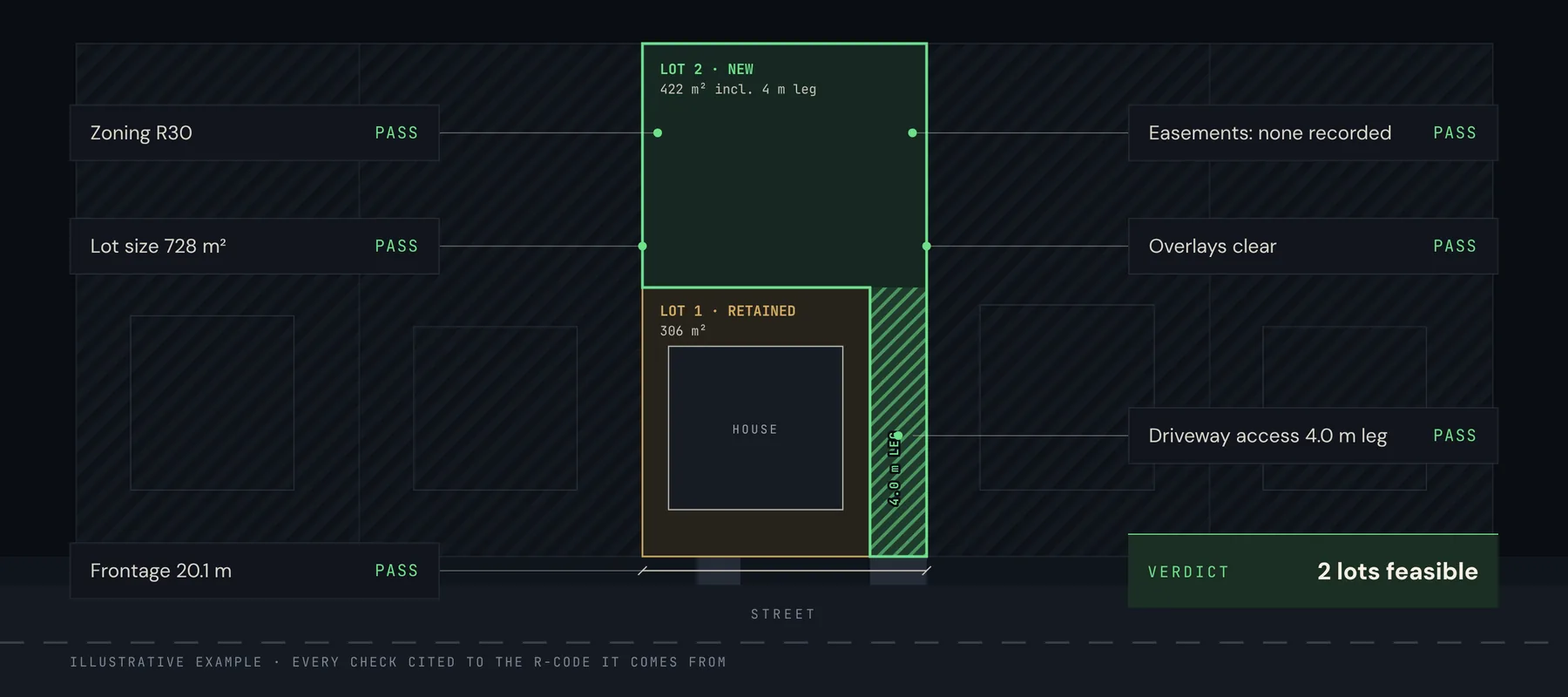
What a free check returns: every control tested against the parcel, each
one cited to the R-Code it comes from. Illustrative example.
We check the parcel boundary, area, R-Code, frontage, driveway access and existing
buildings, then email you the assessment with a drawn layout.
1. R-Code zoning — the number that decides everything
Every residential lot in Perth carries a density code from the WA Residential
Design Codes (State Planning Policy 7.3) — R2 through R160. The code is set by
your local government's town planning scheme, not by the state, and it is the first
thing to find out, because it fixes the minimum and average lot area you have to hit.
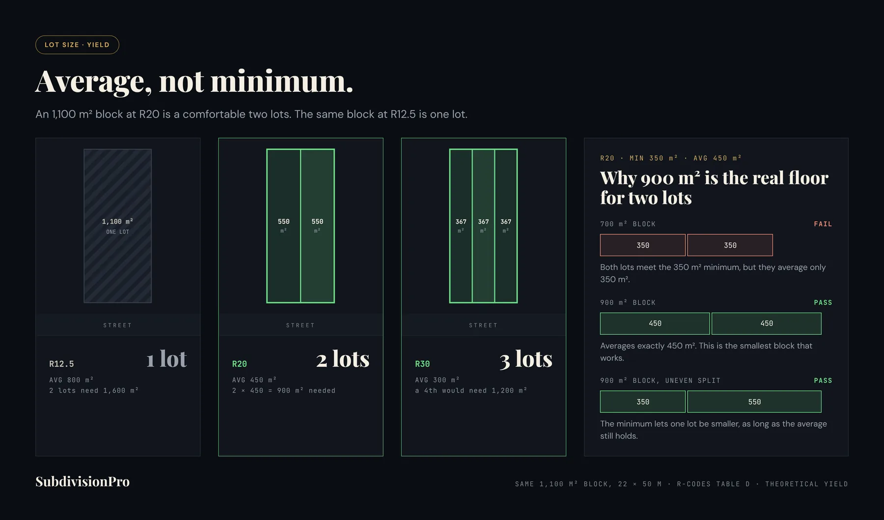
An 1,100 m² block at R20 is a comfortable two lots. The same block at R12.5
is one lot, and no amount of clever design changes that.
The table below is Table D of the R-Codes Volume 1 — the site area
requirements. It is the same table this tool checks every Perth listing against
each morning.
R-Code
Min lot
Average lot
Min rear lot
Min frontage
Multiple dwelling avg
Max site cover
R2
5000 m²
5000 m²
—
50 m
Volume 2
20%
R2.5
4000 m²
4000 m²
—
40 m
Volume 2
20%
R5
2000 m²
2000 m²
—
30 m
Volume 2
30%
R10
875 m²
1000 m²
925 m²
20 m
1000 m²
40%
R12.5
700 m²
800 m²
762.5 m²
17 m
800 m²
45%
R15
580 m²
666 m²
655 m²
12 m
666 m²
50%
R17.5
500 m²
571 m²
587.5 m²
12 m
571 m²
55%
R20
350 m²
450 m²
450 m²
10 m
450 m²
60%
R25
300 m²
350 m²
425 m²
8 m
350 m²
60%
R30
260 m²
300 m²
410 m²
not applicable
300 m²
60%
R35
220 m²
260 m²
395 m²
not applicable
260 m²
65%
R40
180 m²
220 m²
380 m²
not applicable
115 m²
65%
R50
160 m²
180 m²
160 m²
not applicable
100 m²
70%
R60
120 m²
150 m²
120 m²
not applicable
85 m²
70%
R80
100 m²
120 m²
100 m²
not applicable
Volume 2
75%
R100
100 m²
120 m²
100 m²
not applicable
Volume 2
80%
R160
100 m²
120 m²
100 m²
not applicable
Volume 2
80%
Table D, R-Codes Volume 1, in effect 10 April 2026. Min lot and
average lot apply to single houses and grouped dwellings. Min rear lot is
the floor for a battleaxe lot including its access leg, and by Table D's own
footnote applies to single houses. A frontage of not applicable means Table D
sets none at R30 and above — the real floor there is the minimum access width. At
R80 and above the multiple-dwelling figures defer to R-Codes Volume 2. Always confirm
your code with your local government.
Dual and triple density codes
Plenty of Perth lots are coded twice — R20/40, R20/50 —
and some three times, like Cockburn's R30/40/60 in Hamilton Hill. The higher number
is real but conditional: the scheme text attaches requirements before you can
use it, and those conditions belong to the local government, not the state. Common
ones are sewer connection, a minimum lot area larger than Table D's, frontage to a
particular street, a structure plan being in place, or amalgamation with a
neighbour.
This matters more than anything else on the page, because the gap between the halves
is usually the difference between two lots and four. If your code has a slash in it
the uplift is worth chasing — and worth confirming in writing before you pay
for anything.
2. Lot size — how many lots your block actually yields
Yield is not lot area divided by the minimum. It is divided by the average,
and then every resulting lot must still clear the minimum on its own. At R20 that
means an average of 450 m² per lot with no lot under 350 m².
Block area
R12.5
R15
R17.5
R20
R25
R30
R40
R60
500 m²
1 lot
1 lot
1 lot
1 lot
1 lot
1 lot
2 lots
3 lots
600 m²
1 lot
1 lot
1 lot
1 lot
1 lot
2 lots
2 lots
4 lots
700 m²
1 lot
1 lot
1 lot
1 lot
2 lots
2 lots
3 lots
4 lots
800 m²
1 lot
1 lot
1 lot
1 lot
2 lots
2 lots
3 lots
5 lots
900 m²
1 lot
1 lot
1 lot
2 lots
2 lots
3 lots
4 lots
6 lots
1,000 m²
1 lot
1 lot
1 lot
2 lots
2 lots
3 lots
4 lots
6 lots
1,200 m²
1 lot
1 lot
2 lots
2 lots
3 lots
4 lots
5 lots
8 lots
1,500 m²
1 lot
2 lots
2 lots
3 lots
4 lots
5 lots
6 lots
10 lots
2,000 m²
2 lots
3 lots
3 lots
4 lots
5 lots
6 lots
9 lots
13 lots
Theoretical maximum from the Table D average site area alone. It ignores
frontage, the land a rear lot gives up to its access leg, the existing house, overlays
and anything the local scheme adds — all of which routinely take a lot off the total. Treat it
as the ceiling, never the answer.
Yield runs off the average, not the minimum. At R20 that makes
900 m² the real floor for two lots — a 700 m² block clears
the 350 m² minimum twice over and still fails.
The two commonest reasons a big enough block still does not split:
nowhere to put the driveway, and a house sitting across the future boundary.
The existing house is part of the maths
A subdivision almost always has to work around the dwelling already there. Three
outcomes, in rough order of how often we see them:
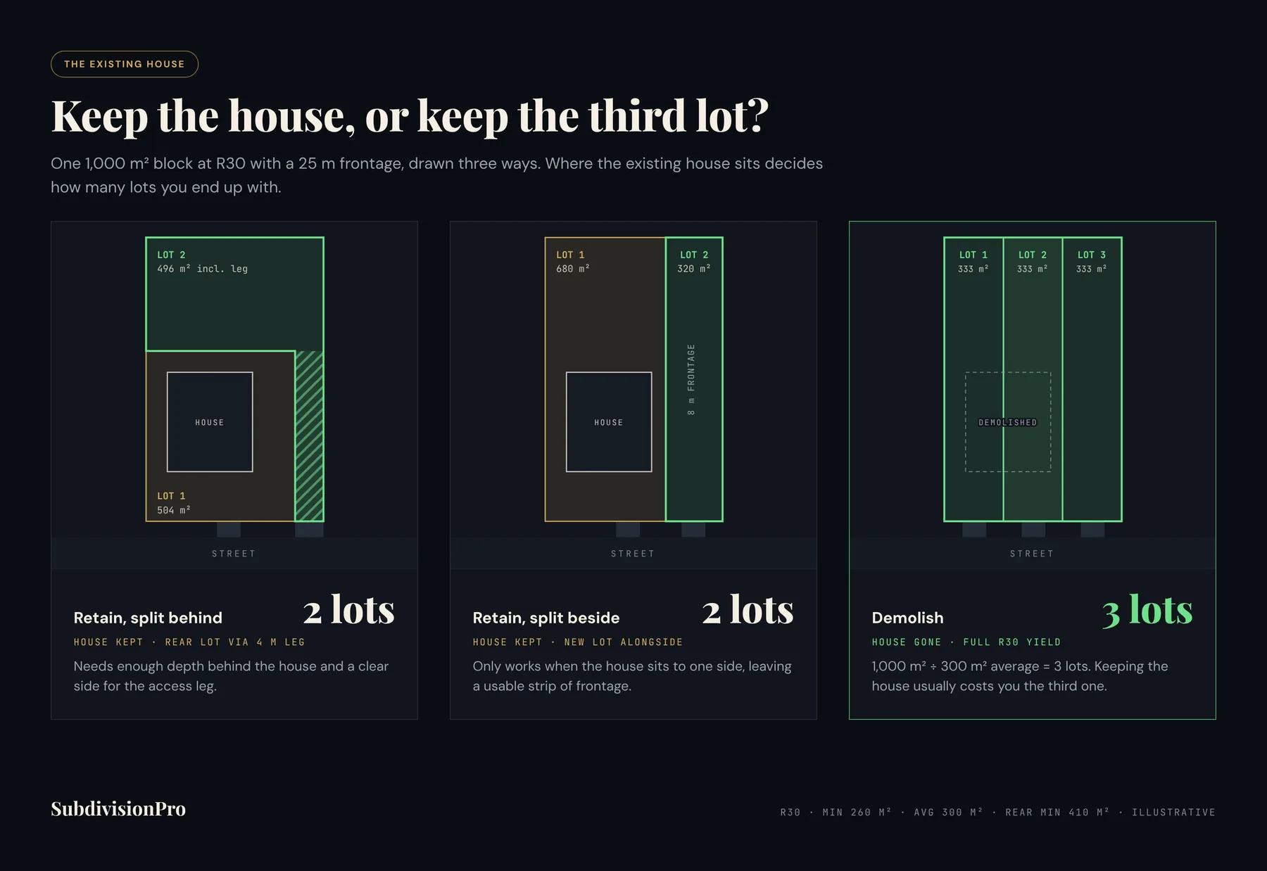
Retain and split behind. The house stays on the front lot and a new lot is
created at the rear, with a driveway past the side of the house. Cheapest, and the
reason side setbacks and the width of that side strip decide so many deals.
Retain and split beside. Works on a corner or a very wide frontage, where
both lots can front a street directly. The cleanest result when it fits.
Demolish. Frees the whole site to be designed properly and usually yields
the most lots, and you give up the house and any rent it was earning. Sheds and small
outbuildings under about 30 m² generally do not change the answer; a
garage, granny flat or pool does.
The same block, three ways. Keeping the house is usually what costs you the
third lot — 1,000 m² divided by R30's 300 m² average is
three, but only with the site clear.
3. Frontage — the width at the street
Frontage is the measurement along your street boundary. Up to R25 Table D sets a
hard minimum per lot — 10 m at R20, 8 m at R25. At R30 and above it
sets none at all, which does not mean zero: the practical floor becomes the narrowest
strip that can legally carry a vehicle crossover, so a lot still needs width for its
driveway, its crossover, and the verge trees and services already in it.
Two frontage traps worth knowing:
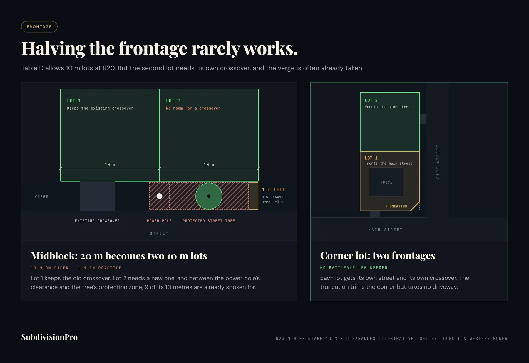
Splitting the frontage in half rarely works. A 20 m frontage at R20
gives two 10 m lots exactly on the minimum — before you account for the
existing crossover, a power pole, or a street tree the council will not let you
remove.
Corner lots have two frontages and usually a truncation at the corner.
That is normally an advantage: two street frontages can mean two lots with direct
access and no battleaxe leg at all.
Ten metres on paper, one metre in practice. A corner lot is the opposite
case — two frontages, two crossovers, no access leg. Verge clearances are
illustrative; council and Western Power set the real ones.
4. Access — the driveway, the battleaxe and common property
If a new lot does not touch the street it needs a legal way in. Under WAPC
Operational Policy 2.2 that access has a minimum width, and every square metre of it
is land the rear lot has to count toward its own area.
Density
Minimum access width
Typical arrangement
Up to R40
4.0 m
Battleaxe leg on green title, or a common property driveway on
survey-strata
R50 and above
3.6 m
Common property driveway; shared access becomes the norm
WAPC Operational Policy 2.2, cl 4.5.7. The width is a legal minimum, not
a design target — councils regularly want more for bin collection, passing bays,
turning at the end of a long leg or emergency access, and long driveways attract more
conditions than short ones.
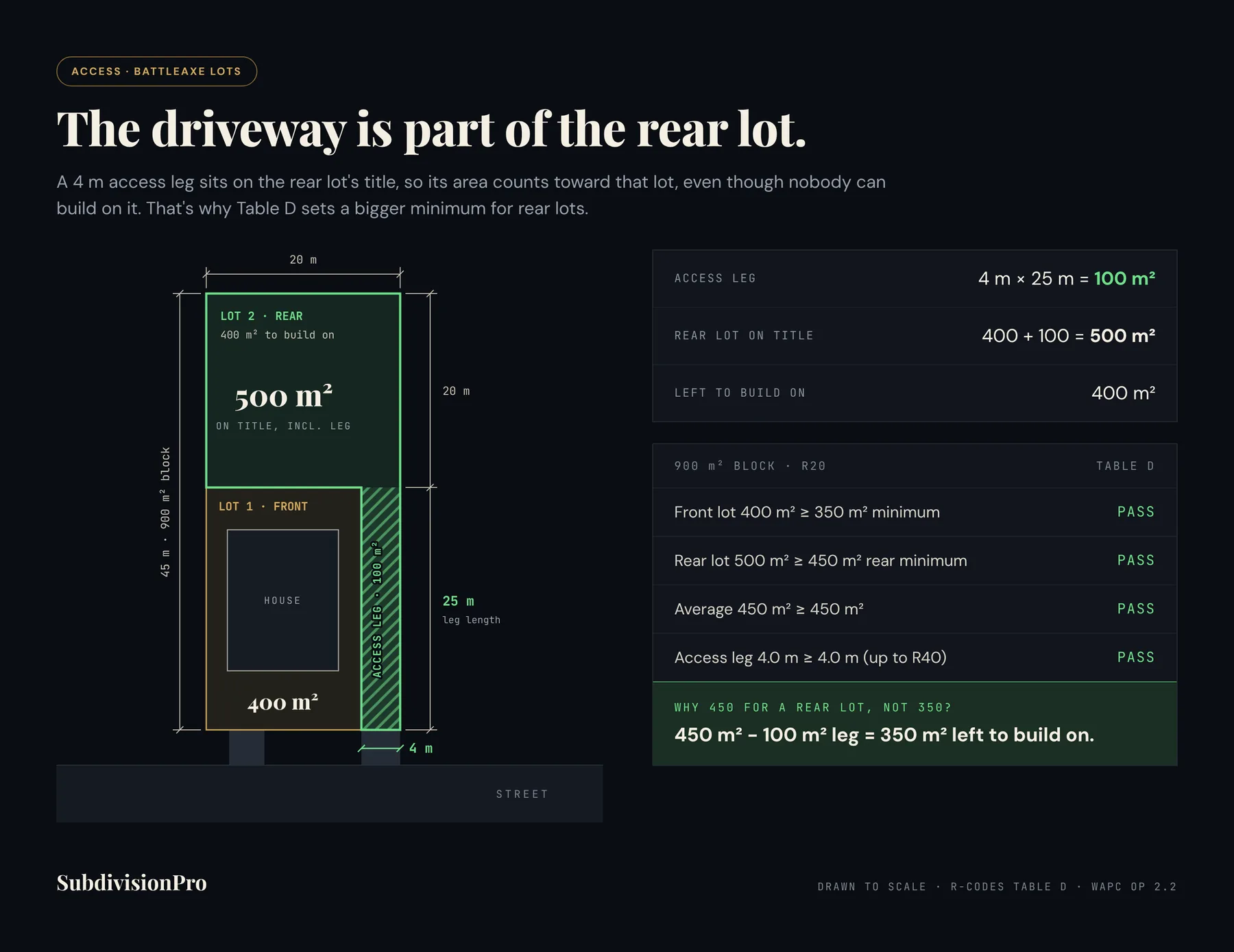
A battleaxe lot carries its own driveway. The leg is on the rear lot's
title and counts toward its area, which is why Table D sets a separate, larger
minimum for rear lots. Drawn to scale, R-Codes Table D and WAPC OP 2.2.
Why the access leg counts twice
A 4 m leg running 25 m down the side of the house is 100 m² of
land. That land counts inside the rear lot's area, which is exactly why Table D sets a
separate, larger minimum rear lot figure — 450 m² at R20
against a 350 m² ordinary minimum. Then it has to be built: crossover,
paving, drainage, and often a retaining wall.
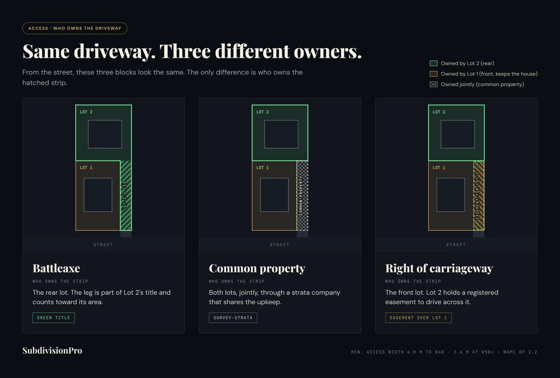
Three variants you will meet:
Battleaxe. The leg is part of the rear lot's title. Full control, full area
penalty, green title outcome.
Common property. The driveway is owned jointly by the lots that use it
under a survey-strata scheme. Less area penalty per lot, but you get a strata
scheme and shared management with it.
Right of carriageway. An easement over someone else's land. Occasionally
the only option; expect the council and the WAPC to take more convincing.
From the street all three look the same. The difference is whose title the
driveway sits on — and that decides whether you end up with green title, a
strata scheme, or an easement.
5. Green title or survey-strata?
Both produce separate, sellable titles. Which one you choose changes the rules you
are tested against, so it is a planning decision, not a paperwork one.
Green title (freehold)
Survey-strata
What you own
The lot outright, to the boundary
A surveyed lot plus a share of common property
Shared driveway
No — each lot needs its own access or a
battleaxe leg
Yes — a common property driveway is the normal solution
Minimum rear lot rule
Applies (Table D footnote)
Generally not applied to survey-strata lots
Ongoing obligations
None beyond rates
Strata company, insurance for common property, shared maintenance
Buyer perception
Usually the premium product
Some resistance, improving as infill normalises
Typically used for
Two or three lots with real street frontage
Rear lots, narrow blocks, three or more lots behind one driveway
General comparison only. Which is available to you depends on your code,
your frontage and your local scheme — some councils actively prefer one over the
other in particular precincts.
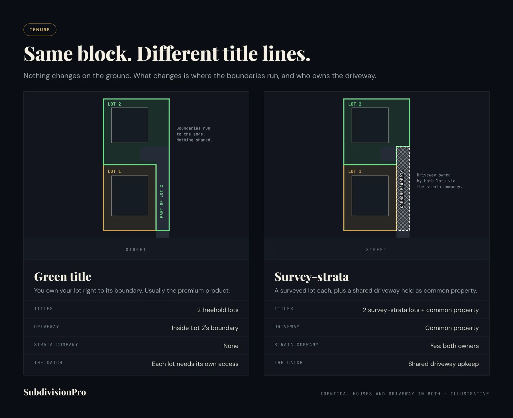
Nothing moves on the ground. What changes is where the title boundaries run
and who owns the driveway — which is why tenure is a planning decision, not
paperwork.
6. Overlays and site constraints
Zoning tells you what the land is for. Overlays and constraints tell you what
is wrong with it, and they override an otherwise perfect R-Code every week.
None of these necessarily kills a subdivision — most add time, conditions and
work — but they all have to be found before you buy, not after.
Constraint
What it does to a subdivision
Where to check
Bushfire prone area
Triggers a Bushfire Attack Level assessment and a bushfire management plan; can force building envelopes, wider access and asset protection zones.
DFES Map of Bush Fire Prone Areas
Heritage listing
Demolition may be refused outright, and new lots and built form are assessed against the listing. Turns “demolish and redesign” into “retain and work around”.
Local heritage list, or the State Register
Character or precinct area
Local policy on lot sizes, street setbacks and retention of original dwellings, commonly stricter than the R-Codes.
Local planning policy, your council
Flood or inundation
Fill and drainage requirements, minimum floor levels, and sometimes no additional lots in the affected part of the site.
DWER floodplain mapping, council drainage
Acid sulfate soils
Investigation and a management plan before earthworks or dewatering.
DWER acid sulfate soil risk mapping
Contaminated sites
Site investigation, possibly remediation, before titles issue. Watch former market gardens, service stations and sheds with fuel storage.
DWER Contaminated Sites Database
Significant trees and vegetation
Retention conditions can dictate where the driveway and the building envelopes go, and occasionally rule out a lot outright.
Council tree register, local policy
No sewer connection
Infill subdivision generally needs reticulated sewer. Unsewered land means an extension by you, and it is a standard condition on dual-density uplift.
Water Corporation
Easements and services
A drainage or power easement, or a sewer main crossing the site, can make a lot unbuildable even at a compliant area.
Certificate of Title, Dial Before You Dig, Water Corporation
Regional road reservation
Land reserved under the Metropolitan Region Scheme for a future road or other public purpose is effectively unavailable, so your usable area shrinks.
Metropolitan Region Scheme maps
Aircraft noise
Density limits and noise attenuation near Perth and Jandakot airports.
SPP 5.1 ANEF contours
Structure plan area
Lot layout, staging and sometimes density are already set by the approved plan, so you design to it rather than to the R-Codes alone.
Your council’s approved structure plans
Not exhaustive, and local schemes add their own. The free check above
covers zoning, area, frontage, access and existing buildings — the overlays are a
due-diligence step, and the reason a planner's pre-purchase opinion is worth
getting.
7. The process, step by step
Perth subdivision runs through the Western Australian Planning Commission, not your
council — the council is a referral agency with a great deal of influence, but
the WAPC issues the approval. The sequence is almost always this:
1
Check the zoning and the site before you commit
Find the R-Code, the lot area, the frontage and whether a driveway can physically reach the rear. This is the step that decides whether there is a project at all, and the only one that is free — the form at the top of this page does it against the state cadastre and planning layers.
2
Get a concept plan from a surveyor or planner
A licensed surveyor picks up the real boundaries, levels, buildings, trees and crossovers, and a concept plan tests a lot layout against the R-Codes. Expect the first concept to change: the driveway is usually what moves.
3
Talk to the council before you lodge
The local government is a referral agency on every subdivision and its advice shapes the conditions you will be given. A pre-lodgement conversation about setbacks, the crossover, trees and drainage saves more trouble than any other hour you will spend on it.
4
Lodge the subdivision application with the WAPC
The application goes to the Western Australian Planning Commission with the plan of subdivision. The WAPC refers it to the council and the servicing authorities, and has 60 to 90 days to decide, depending on lot count.
5
Receive conditional approval
Approvals are granted subject to conditions, with a sunset date — commonly three or four years for infill. Read the conditions as the real scope of works, because that is what they are.
6
Clear the conditions
Services to each lot, the crossover and driveway, drainage, earthworks and retaining, demolition or building modification, contributions, and any management plan an overlay triggered. This is by far the longest stage.
7
Survey, deposited plan and new titles
The surveyor sets the new boundaries and lodges a deposited plan, or a strata plan for survey-strata. Landgate issues the new titles, and only then can a new lot be sold or built on.
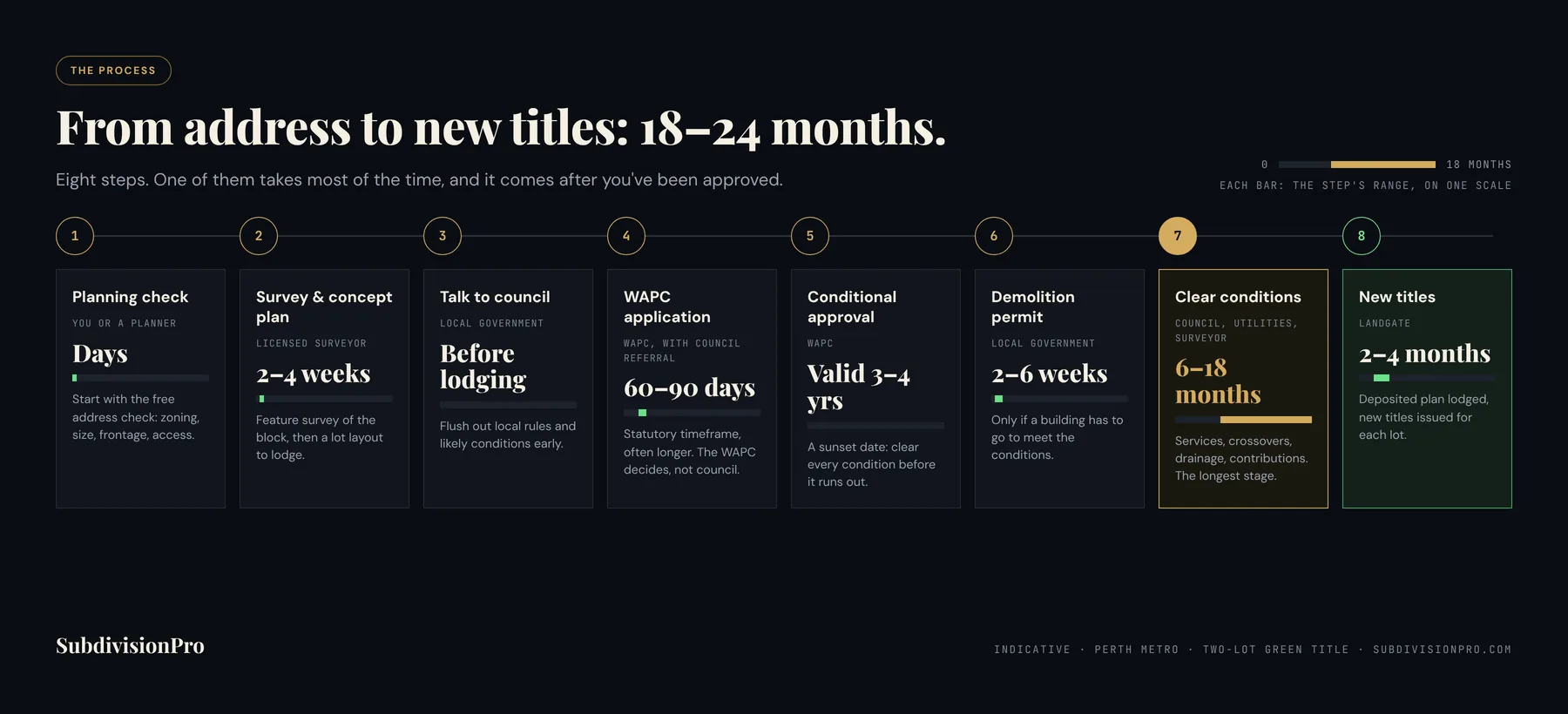
Clearing the conditions is the long pole, and it comes after you have
been approved. Indicative only — Perth metro, two-lot green title.
8. Approvals and timeframes
Who signs what, and roughly how long each step takes. Treat every duration as an
order of magnitude for a straightforward two-lot green title subdivision in the Perth
metro area — a complicated site, a strata scheme, or anything that ends up at
the State Administrative Tribunal runs longer.
Step
Who decides
Indicative time
What comes out of it
Pre-purchase planning check
You, or a town planner
Days
A yes, a no, or the one thing to go and confirm
Feature survey and concept plan
Licensed surveyor
2–4 weeks
Real boundaries and levels, and a lot layout to
lodge
WAPC subdivision application
WAPC, on council referral
60–90 days statutory, often longer
Conditional approval, or a refusal you can review
Demolition permit, if demolishing
Local government
2–6 weeks
Permission to clear the site
Clearing the conditions
Council, Water Corporation, Western Power, surveyor
6–18 months
Every condition signed off — the real
project, see below
Survey, deposited plan, new titles
Landgate
2–4 months after conditions cleared
Separate titles you can sell or build on
Indicative only — Perth metro, two-lot green title, as a planning
sanity check. A site with a long driveway, retaining, or a service extension takes
longer at almost every step, and statutory timeframes are the floor, not the
expectation.
What the conditions usually are
WAPC approval arrives conditional, with a sunset date — commonly three or four
years for an infill subdivision. Clearing the conditions is the real project:
Services to each lot. Water and sewer through the Water Corporation, power
through Western Power, plus telecommunications and gas where required. The single
biggest source of unexpected work, especially where a main has to be extended.
Crossover and driveway built to council specification, the old crossover
removed and the verge restored.
Drainage. On-site stormwater disposal sized to the council's standard.
Earthworks and retaining so each lot is usable and drains correctly.
Demolition or building modification where a structure crosses a new
boundary or breaches a setback.
Contributions. Development contributions where a scheme imposes them, and
public open space — cash in lieu, on smaller infill subdivisions.
Management plans for bushfire, contamination or heritage, where an overlay
triggered one.
If the WAPC refuses, or imposes a condition you cannot live with, there is a right of
review to the State Administrative Tribunal within 28 days. It is a genuine option and
a used one — but budget time and a planning consultant for it.
Perth subdivision FAQ
How do I find out if my property can be subdivided? Start with four things: the R-Code in your local government’s town planning scheme, your lot area from the certificate of title, your street frontage, and whether a compliant driveway can reach the rear of the block. If the area clears the Table D average for your code and the access works, you have a candidate — then check the overlays. The free check at the top of this page tests those four against the state cadastre and planning layers and emails you the result.
What is the minimum block size to subdivide in Perth? There is no single number, because it depends on your R-Code. At R20 — the most common code in established Perth suburbs — two lots need an average of 450 m² each, so roughly 900 m², and a rear battleaxe lot has to reach 450 m² including its access leg. At R30 the average drops to 300 m², and at R12.5 it rises to 800 m².
Can I subdivide and keep my house? Usually, and it is the most common infill outcome in Perth: the house stays on the front lot and a new lot is created behind it, with a driveway running past the side of the house. It works when the side strip is wide enough for a compliant access leg, the house does not cross the new boundary or breach a setback, and the rear lot still clears the minimum rear lot area with the leg included.
Who approves a subdivision in Western Australia? The Western Australian Planning Commission, not your local council. The council is a referral agency — influential on the conditions, but not the decision-maker — and so are the servicing authorities. Landgate issues the new titles once the conditions are cleared.
How long does a subdivision take in Perth? The WAPC has 60 to 90 days to decide the application, but clearing the conditions is the long part: six to eighteen months is typical for a straightforward two-lot infill subdivision, then another two to four months for the survey, the deposited plan and the new titles. Budget eighteen months to two years end to end.
What are the main stages of a Perth subdivision? Check the zoning and the site, get a feature survey and a concept plan, talk to the council, lodge the application with the WAPC, receive conditional approval, clear the conditions, then survey and lodge the deposited plan so Landgate can issue the new titles. Clearing the conditions — services, crossover, drainage, earthworks and retaining — is by far the longest stage.
What does a dual density code like R20/40 mean? The lot is coded twice, and the higher density is available where the local government’s scheme text conditions are met — commonly sewer connection, a larger minimum lot area, frontage to a particular street, or a structure plan being in place. The uplift is real and often doubles the yield, but it is conditional, and the conditions are the council’s, so confirm them in writing before you buy.
What is the difference between green title and survey-strata? Green title gives you the lot outright to the boundary, with no shared land and no ongoing obligations beyond rates, but each lot needs its own access or a battleaxe leg. Survey-strata gives each lot a surveyed title plus a share of common property, which is how a shared driveway is normally handled, in exchange for a strata company and shared maintenance. Green title usually sells for more.
What is a battleaxe block? A lot behind another one, reached by a narrow leg of land running out to the street and forming part of its title — a shape like an axe head on a handle. The leg must be at least 4.0 m wide up to R40 and 3.6 m at R50 and above, and its area counts toward the rear lot’s own, which is why Table D sets a larger minimum for rear lots than for ordinary ones.
Can a subdivision be refused even if my block is big enough? Yes, and area is one of the commoner things to clear while something else fails. Insufficient frontage, no room for a compliant driveway, a house across the proposed boundary, a heritage listing, bushfire requirements, no sewer connection, a significant tree, or an easement through the middle of the new lot will all do it. If the WAPC refuses there is a right of review to the State Administrative Tribunal within 28 days.
Find out about your block in about a minute
Put your address into the form at the top of this page and
we will check the cadastre, the R-Code, the frontage, the driveway access and the
buildings on it, then email you the assessment with a drawn layout. Free, no account,
no card. Or browse the Perth suburbs where blocks are
currently passing the pre-check.